Automated transcript · Written by software from the replay's audio. It can mishear names and figures; the replay is the record.
1:07 What I would also like to say is that, you know, any kind of drilling program always comes up with new information and sometimes surprises. So that's what's happened in this case. So what I'd like to do is go through the most recent one that came out this morning, most recent press release that came out this morning, and it sort of summarizes everything but highlights one of the, I think, the best intersections we've had on the property so far. So I'll start with that. And what I'll do is I'll just walk through it, highlight some of the images and some of the core photos and give some context to those for the viewers to look at. So first of all, I guess the thing to keep in mind here is that we've got some multi percent copper equivalency numbers over bigger than 10 meter intervals, which is what we had hoped to see originally, you know, from the visuals, and it's certainly played out in this case.
2:06 So 1.56 over 1475 metres. And the other thing too, is that it's not just 1 zone within these drill holes, And we can look at sections in a minute, but it's the entire holes are actually mineralized consistently right through it. Some higher grade, some medium, some lower grade, but it shows that there's a pretty good size system here and then it needs to be followed up. So we'll touch base on that as we go through this. So yes, hole number 4 was the one we were waiting for. Finally, the numbers came through. The assay labs have been backed up all summer. We weren't alone, just about everybody else was in the same boat as us. So we just had to wait for them and they came all at once. So hence the 2 releases in 1 week.
2:55 The other thing that I'd like to talk about this release too is this second target that we intersected in hole number 1, which was a banded iron formation. And banded iron formations are very good for hosting gold systems. And in this case, because this whole Wabagoon Greenstone Belt is very rich and well endowed in gold mineralization all the way through it. It's not surprising, hence, that we are seeing some gold in the banded iron formations on Centrefire. So we'll go and have a look at that as well. So working through this, just I've got 2 screens going here, but what I'll do is I'll stop here and we'll have a look at the highlights of hole number 4.
3:42 And as I mentioned, we've got, the entire hole is mineralized and we've taken that across basically 122m from top, basically right to the bottom. We're running at 0.42 Copper equivalency. Now, just to make sure everybody understands what that means is we're taking the Copper, the Gold and the Silver numbers, applying a factor based on the prices in the market, a discounted price in the market, and then giving it an equivalency in Copper value basically. So 0.232 Copper, 0.185 Gold and 1.1g Silver over the entire length of the hole. So that's impressive on its own. But within that zone or within that hole, we're getting a couple of higher grade zones.
4:33 So the one that I think we'd like to look at and just to show people that we've got something significant here is that there's a 14, sorry, a 29.6 meter section over 1% copper. And within that, a 14.75 meter section of 1.56 Copper equivalency. And again, you can see the numbers, the Copper numbers are pretty close to almost 1%. And the Gold is almost 1g and the Silver is certainly over 2.8. So, it's a mineralizing system. And as I mentioned before, it's a bit of a surprise to see the silver numbers and the gold numbers. Historically, they weren't looked at.
5:18 Historically, this was thought of as being a true VMS, or Volcanogenic Mass of Sulfide System. And typically you just see copper, you see nickel, you see some lead, you see some zinc in the system. Well, we're not seeing lead and zinc. We're seeing maybe a wee bit of nickel, but we're finding in this case, we've got quite a bit of gold and silver. So, it's made us rethink our model on what we're seeing here. And we don't believe now that it's a VMS system, at least where we're hitting in this hole and the previous 2 holes. So we can have a discussion about that in a second. But what I wanted to do is just to start with at least the highlights of what we've hit in this CF 2604 hole.
6:08 So what I'd like to do next, and we can come back to this, but this is a summary of all the intersections we've hit. And just maybe as a reminder, in hole 3, which was drilled a bit more shallow cut on the same intersection. Again, it was 0.42% copper equivalency over 71 meters. And then again, within that, we had some really nice high grade intersections, 10.75 meters of 1.18 copper equivalency. Hole number 5, which was a angled hole away from the zone, but still under, well, off to the side of the outcrop exposure, we're calling the main Gossan zone or the MGZ. Again, the entire hole running 0.46% copper equivalency with some nice high grade, 10.5 of 1.27% copper equivalency. So 3 holes, 3 intersections of major plus 1% copper. So just as a reminder there.
7:15 What I'd like to look at next is just some of the mineralization, some of the grades that we're seeing within that hole number 4, the one that we've just released this morning. So at the top of the hole, you can see this is, I'm going to maybe zoom in a little bit more to make it a little bit more visible for the, there we go. So right from the top of the hole at 6.6 meters and then above that was overburden basically. So sand and gravel and that kind of thing. And again, we're drilling at a bit of an angle so It's not a true depth of overburden. I would estimate it to be about 4, 4.5 meters of overburden. But right off the bat, not the first sample, but the second one, almost 0.6% Copper, 2.4 grams Silver. And then, you know, a couple of those smaller intersections of lower grade material and then ramping up to 0.3 and then up to 1.5% copper. Now this is copper, not copper equivalency.
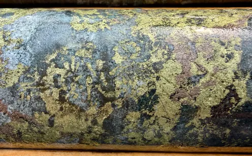
8:18 This is copper. Then 1.39. There are some intervals that are a little lower grade in between, but still fairly decent. 0.36, 3.36, almost 1 percent. So you can see the consistency of the mineralization all the way through it. And I can show you a couple of other intersections here as we go down. You know, there's 0.4, 0.859, 0.618. So consistent numbers, one after the other. And then what I'd like to show you is just what does it look like in core without the numbers and the writing on it. And this is basically just a pure zone from 29 up to, I think it was 43.2 or something like that. And this was the intersection that ran well over 1% copper. And you can see here, we've shown some visuals in the, in press releases before, but you can see the chalcopyrite, which is the copper sulfide mineral that's carrying all the copper.
9:28 And I am, I am assuming that it's carrying, the gold and the silver as well. So anytime where you're seeing the chalcopyrite, you know you've got some great grades and it's not just these big blobs, but you can see it running all the way through this kind of material. And it's associated with the carbonates and quartz veining as well. So this is why we're thinking it's a different system now than a VMS. We're seeing these quartz carbonate veining, we're seeing these wispy and veins of, wispy sections and veins of chalcopyrite. So this is why we're thinking it's a hydrothermal system. It's probably driven by some kind of heat engine, which could be an intrusive either at depth or a long strike or nearby.
10:16 So we've really, we've changed our model, but nonetheless, the fact that we've got this kind of grades and these kind of numbers and this kind of widths are still very encouraging. And that's why we're planning a phase 2 drill program right away to get in there and follow up on this. So I'll just go through the sections here. Now this table is just telling us where the drill hole collars are. It's usually good to include that if people want to look at it and plot it themselves, they can do that. Now this is a plan map that shows where we were drilling. And you'll see that here's CF2604, 2603 was drilled on the same section at a shallower angle. So, 04 was drilled deeper. And the reason for that was to see if there was continuity at depth. We're seeing that surface in that Gossan zone, which is the outcrop. We're seeing it in a shallow cut in hole 3, and now we're seeing it at depth in hole 4. So it really puts together a picture of what's happening with that mineralization.
11:22 You have to remember, this is the first drill program, modern drill program ever, that's been put on this property. You can see some of these old drill holes here. They were done by Placer, no, who was it? Yeah, Placer Dome? No, Pelps Dodge, sorry, Pelps Dodge back in 1968. So quite a few years ago. So they didn't have all this information. They didn't have the ability to do the inversion mag, the inversion VTEM survey, and the interpretation. So they were kind of drilling blind, and obviously they didn't drill in the right spot. But we have, as far as we're concerned. And you can see this is hole number 5 coming off here. As I mentioned, it cuts off to the side to look at that strike extension. And yes, we're seeing it in hole 5 as well. So this gives us very good confidence that this is a continuous zone. And the other thing that you have to look at too, is that we've got this airborne VTEM conductor axis that basically is outlining the potential strike extent of this main Gosselin zone along strike and hopefully at depth as well. So the next program obviously will be to follow up and drill off to the side and drill deeper down under this main Gossan zone. And then I'd like to show you also where hole 1 was drilled and hole 2, And I'll tell you about hole 2 in a second, but hole 1 was drilled more on a magnetic anomaly. And you can see this is a
12:53 magnetic high axis here with a certain amount of conductive response as well. This more purple line is the VTEM axis. So we were tracing a different type of target than we were at the mean Gaussian zone. So hence the difference in the assay results. And those assay results are shown a little bit later, but okay, well, let's quickly look at the section. This is a cross section looking east on hole number 4. You can see the mineralization very close to the surface. Hole number 3 would have come across here and would have caught and it did catch this material at the top. What's what interesting in this this particular hole is we've got this main zone at the top we've got a secondary zone here and then a hint I think there's a hint showing that we may be, you know, we've got something else coming in at depth here. We can see these numbers starting to rise similar to what we were seeing up at the top of the hole. So interesting that, you know, a deeper cut, stepping back and deeper cut on this would probably give us some more information and see whether that is in fact true.
14:08 So incredibly excited about what we've been intersected here. We're really keen to get back and do some more drilling. And one of the things I wanted to show you was, I'm going to zoom out a little bit on this. This was drill hole number 1. And as you recall, it was a different target area, and it was targeting the banded iron formation. So What we did hit was certainly the banded iron formation in this area here and another one down at this area here. And this one was running
16:35 Thank you, Jeff, for that. I appreciate the update. For people just tuning in, we are taking questions if you have any, so do submit your questions. To kick off though, Jeff, Both releases reported the intercepts as drilled lengths. Do you have a good sense yet of true widths and how the mineralized zone is oriented? And what's the one thing phase 2 needs to prove for Centerfire to start looking like a resource story? Yeah, resource, yeah, that's a hole for sure. We're still early, early days for that. But I would say that true widths are still probably unknown because even though we've got 2 cuts on this particular hole, I haven't showed hole 3 in this area. It's still a bit early in our interpretation.
17:22 It hasn't been fully completed on this system, but I would say that it's probably a steeply dipping system. So we're probably looking at about, I don't know, about 30 meters wide of this main zone at the top here. This zone may be a similar width, maybe not quite as high grade. And this one down below, Who knows, it could be just the tip of the iceberg here. So, you know, those are pretty significant widths that could be easily mined at some point. But like I said, we're still early, early days. The program, the next program will be to follow up on, as I mentioned, the strike extent of this, but also it gives us more information about how the geophysics or how, yeah, what the geophysics is telling us about the rock as we're seeing it in the drawing. So then we can take that information and look for similar geophysical signatures that we see along stripe, and then we can target those as maybe more of these hydrothermally altered systems that are coming from a deeper seeded or a tertiary or secondary area of intrusive activity. So yeah it's still early days. I'd like to say we could put a resource together but you know give us some time and we'll hopefully we can do it. For sure, we'll be watching.
18:53 Now, you and I spoke quite a bit this year, Centerfire has understandably taken the spotlight, but you have 4 projects in British Columbia as well. How are you deciding which one of them gets attention and dollars next to Centrefire?